
Cashloura [Maulanimirish Hill]
Good walks are even better shared.
Overview
Cashloura [Maulanimirish Hill]
Location: Nestled in the scenic Southern Uplands of Scotland, Cashloura stands proudly at 533 meters, eagerly welcoming hikers and adventurers alike.
Geology: This Marilyn showcases the beauty of sandstone which was formed over millions of years, interspersed with splashes of granite that add character to its structure.
Routes: One of the most favourite routes to the summit is the Whitton Farm Trail. At a moderate 7.5 km, it winds through lush pastures, adding a pastoral charm to your ascent. Allow about 2.5 hours, perfect for a leisurely hike. Make sure to wave to the sheep as you pass!
Summit Features: Upon reaching the summit, you’ll find a modest cairn that has witnessed many a picturesque sunset and countless selfies. It’s the perfect resting spot to take in the awe-inspiring views over the rolling hills.
Terrain Type: Expect trails that are grass-covered with delightful patches of heather, particularly beautiful during the blooming season. A little effort is needed for the rocky outcrops, but nothing an enthusiastic hiker can’t handle!
Views: The summit rewards you with views stretching far across the Galloway Hills. If you time it right, you may catch a shimmering sunset or the mist rolling over the hills in early morning – it’s like nature’s own light show!
Hazards: Along your route, watch for grazing livestock and stay away from overly slippery sections post-rain. Remember, they might be cute, but they can be unfriendly if disturbed!
Nearby Summits: Make a larger trip of your adventure by exploring nearby peaks like Black Hill (514 m) and Mabie Forest (487 m). Think of it as a mountain hop!
Access: Parking is a breeze at Whitton Farm where you can leave your car worry-free. If you’re using public transport, there are services from Dumfries to Moniaive, from where you can summon a taxi.
Facilities: The village of Moniaive houses a few cafes, a definite stop for delightful treats post-hike. Facilities are limited near the mountain, so plan accordingly!
History: Cashloura’s name suggests a historical background linked to farming and pastoral life. Although the hill is low-key, it holds significance in the local culture, often depicted as the tranquil escape from daily hustle.
Whether you’re a seasoned hiker or just looking for a splendid stroll in the hills, Cashloura – with its welcoming paths, friendly livestock, and stunning views – is a Scottish gem that is well worth a visit!
Happy hiking!
Explore routes near Cashloura [Maulanimirish Hill]
Public walks starting within 80 km of this hill. Nearby does not mean a route reaches the summit; check its map and access before setting out.
No public routes are currently listed within 80 km of Cashloura [Maulanimirish Hill] on Walkmates. This does not mean there are no paths here. Explore the map and check local access information before planning a walk.
Route planning notes
These notes describe possible approaches, not verified navigable routes or permission to cross land. Check current paths, local access rules and conditions before setting out.
Whitton Farm Trail
A well-maintained path leading from Whitton Farm through livestock pastures, culminating in a gentle ascent to the summit.
Make a day of it, together
Find someone to share the walk with, or organise a day out along a route you like.
Hill facts and local notes
Classifications
Elevation
297m
974 ft
Prominence
189m
Coordinates
51.6848, -9.1442
W209485
OS Map
85 89
At the Summit
The summit is crowned with a modest cairn and offers a panoramic view of the surrounding countryside, perfect for those Instagram moments!
Terrain & Geology
Primarily composed of sandstone with occasional patches of granite, Cashloura's unique geological makeup contributes to its striking landscapes and offers fascinating insights into the region's natural history.
Views & Scenery
On a clear day, one can spot the distant peaks of the Galloway Hills and the rolling farmlands of the Southern Uplands.
History & Heritage
Name Origin
The name 'Cashloura' is believed to derive from a combination of a local dialect related to 'clearing' and 'hill', hinting at its pastoral roots.
Historical Significance
Rich in folklore, Cashloura is considered a peaceful retreat and has drawings amongst locals as a place for quiet reflection.
Getting There & Facilities
Check current local access restrictions, parking rules and transport timetables before travelling. These notes do not confirm public access to the summit.
Parking
There is a sizeable parking area at Whitton Farm, which is free to use, but do respect the local farmers’ property.
Public Transport
Buses run from Dumfries to the nearby village of Moniaive, where taxis can be arranged to the farm.
Nearby Facilities
The closest café can be found in Moniaive, along with several charming shops. No toilets are available at the summit or along the trail, so do plan accordingly!
Safety Information
Known Hazards
- Beware of livestock in the fields, as well as occasional slippery patches after rain.
General Safety Tips
- Check weather conditions before setting out
- Carry appropriate clothing and equipment
- Let someone know your planned route
- Take a map, compass, and GPS device
- Carry emergency supplies: food, water, first aid kit, torch
Hills
Some common questions about the hills answered
Are there group walks up Cashloura [Maulanimirish Hill]?
Many walkers use Walkmates to join or organise walks with others. You can check for group walks around Cashloura [Maulanimirish Hill] through the maps
Are there other walkers around Cashloura [Maulanimirish Hill]?
Activity varies by location and time, but Walkmates lets you see whether others have shared walks or shown interest in this area. Find other people through the walking friends search walking friends for Cashloura [Maulanimirish Hill] search or of course create your own walk for Cashloura [Maulanimirish Hill]
Can I organise a walk to Cashloura [Maulanimirish Hill]?
Yes. If there aren’t any walks listed already, you can create a walk and make it available for others to join.
If you're signed up to Walkmates, you can create a walk to Cashloura [Maulanimirish Hill].
How do I find a walk up this hill?
There are often multiple ways to walk this hill, depending on experience and route preference. Walkmates helps you explore walks and routes that others have shared.
Can I suggest a new route up Cashloura [Maulanimirish Hill]?
Yes. You can suggest or create routes to share with others. Walkmates focuses on the social side of walking, so routes are used to help people organise walks and explore areas together, rather than as detailed navigation tools or route libraries.
Other uses really appreciate knowledgeable walkers sharing their routes. Share your favourite route to Cashloura [Maulanimirish Hill] here
The is an error or something incorrect about this hill. How do I let you know?
We always strive to keep the information on Walkmates as accurate as possible. If you find an error, please let us know through the contact form and we'll aim to correct it as quickly as possible
Community Discussion
Comments
Location
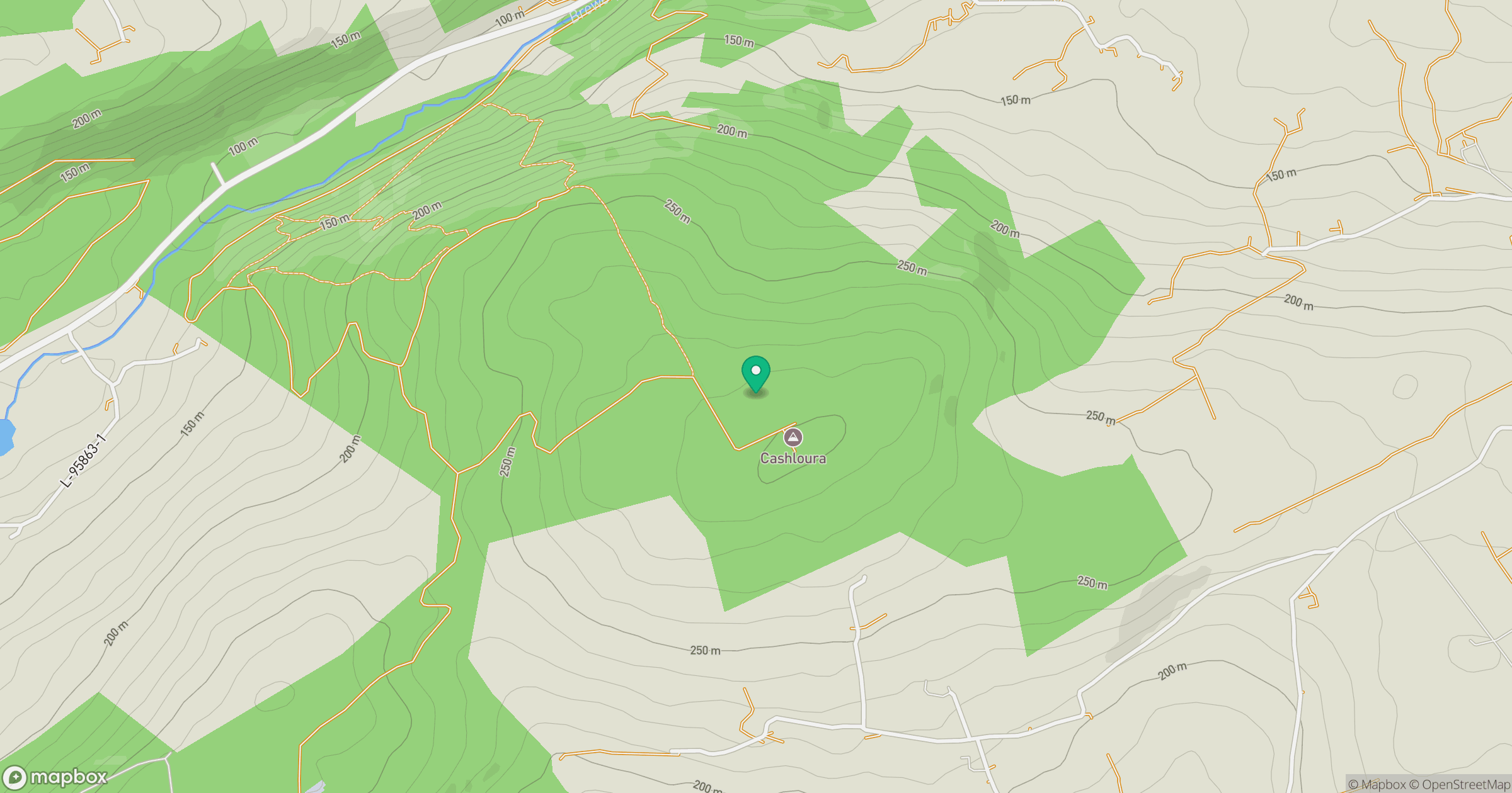
Grid reference: W209485
View on OpenStreetMapOpens a map in a new tab, centred on the hill.
Hills within 30 km
Straight-line distance, not a walking route or confirmation of access.
No comments yet. Be the first.